Search
Recent comments
- a peace deal....
3 hours 34 min ago - peace now!
4 hours 59 min ago - a nasty romance....
5 hours 5 min ago - blackmail?.....
7 hours 36 min ago - ukraine's agony has not started yet....
1 day 1 hour ago - all defeated.....
1 day 1 hour ago - beyond crime.....
1 day 2 hours ago - the end....
1 day 2 hours ago - odessa....
1 day 3 hours ago - weitz....
1 day 5 hours ago
Democracy Links
Member's Off-site Blogs
lorenzo...

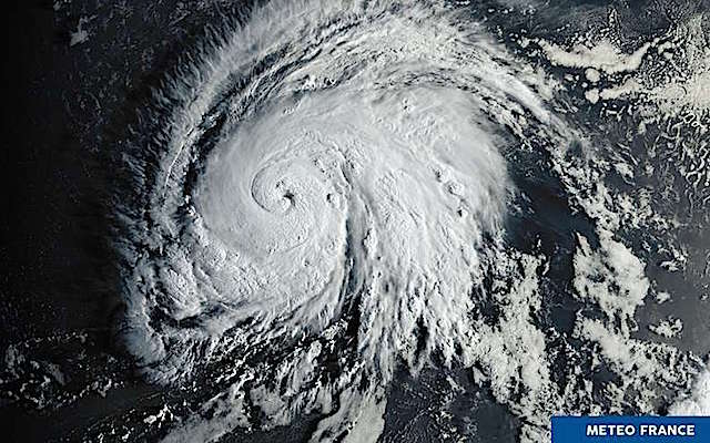
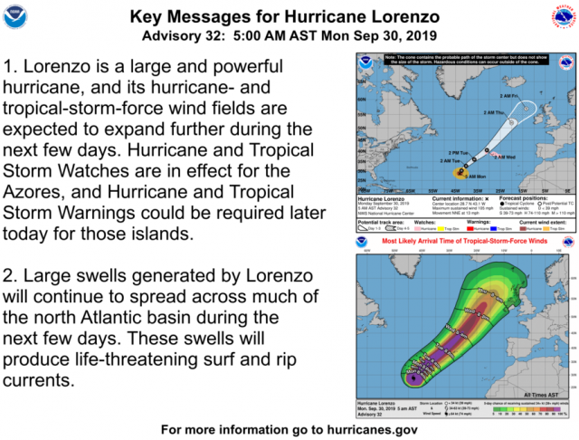
This cyclone, whose winds far exceed 200kmh, is considered the most powerful ever observed in this eastern part of the Atlantic.
It is considered the most intense hurricane ever observed in the northeastern Atlantic basin according to Keraunos ... Hurricane Lorenzo, ranked in category 5, has formed in recent days over the Atlantic Ocean between Africa and the Caribbean and is now approaching Europe's shores.
As Météo-France quotes the National Hurricane Center (NHC), Lorenzo, with winds well over 200 km / h, should soon touch the Portuguese archipelago of the Azores. Heavy rains that can cause significant floods are expected.
Brittany could be affected
If it is still difficult to predict the trajectories of the hurricane, Lorenzo could then go back to the northeast to the British Isles. By then, it should lose intensity and be reclassified into a storm, predict several weather specialists. Brittany could notably wipe some weather related to this hurricane by next Friday.
Hurricane Lorenzo has already done some damage, it is indeed at the origin of the sinking of the tug boat Rhode, in difficulty at sea for several days. For now, three sailors have been found, eleven are still missing.
Read more:
https://www.sudouest.fr/2019/09/30/l-ouragan-lorenzo-classe-en-categorie...

- By Gus Leonisky at 30 Sep 2019 - 8:09pm
- Gus Leonisky's blog
- Login or register to post comments
cycling in the UK rain...
Northern England will face most severe weather conditions and up to 70mm of rain could fall at highest areas
Parts of England and Wales are bracing for further heavy rain with forecasters warning up to 70mm could fall in some areas.
Northern England is set to see the heaviest rain, with weather conditions so severe, Sunday’s Cycling World Championship route from Leeds to Harrogate was shortened from 284.5km to 261km. Riders were taking a shortcut from near Aysgarth to Leyburn to avoid dangerous roads.
The Environment Agency has 61 flood warnings in place for England in counties including Cornwall, Devon, Somerset, Yorkshire, Hampshire, Sussex and Lincolnshire.
Commuters faced treacherous travel conditions as rail networks struggled to cope with the heavy downpour. Northern Rail warned passengers to expect severe delays and cancellations to their journeys on Sunday afternoon.
Trains between Blackpool North and Preston were suspended due to flooding and parts of the Cheshire track were also affected.
Speed restrictions were put in place due to safety concerns causing severe delays on journeys around Wigan, Southport, Leeds, Harrogate and Manchester to Sheffield.
Read more:
https://www.theguardian.com/uk-news/2019/sep/29/england-and-wales-weathe...
Most likely this is the lasting influence of hurricane Humberto that is presently affecting the UK. Then could come Lorenzo... keep you posted...
Meanwhile:
More than 100 people have died due to flooding caused by heavy rains in the Indian states of Uttar Pradesh and Bihar, officials have said.
Dramatic images of the impact of flood water on urban life have been coming out of the affected areas.
Railway traffic, vehicular movement, healthcare services, schools and power supply have been disrupted in both states, officials said.
An Uttar Pradesh government report said 93 people have died since Thursday.
In eastern Uttar Pradesh, flooding caused officials to relocate more than 500 prisoners from the Ballia district jail to other prisons after water entered three buildings.
The Additional District Magistrate told reporters that officials were awaiting permission to move all of the prison's 850 inmates to Azamgarh jail, which is about 120km (74 miles) away.
The death toll in Bihar is 29, according to the state disaster management authority. The impact on its main city, Patna, has been grabbing headlines.
A video of a man struggling to pull his cycle-rickshaw out of flood water has been circulated widely on social media.
In it, the man filming the video can be heard consoling the visibly upset rickshaw puller - he suggests that the man leave the vehicle where it is and return for it after the flood waters recede. He and a woman, who can be heard in the background, offer to keep an eye on it for the rickshaw puller from their spot on the balcony.
Read more:
https://www.bbc.com/news/world-asia-india-49875027
and now hagibis...
The mighty Hagibis typhoon is approaching the southwestern coast of Japan. It could bring heavy gusts and heavy rains on Saturday and Sunday, threatening two scheduled [Rugby] matches on those days.
The organizers of the Rugby World Cup have issued a weather advisory on Monday, as a strong typhoon approaches the southwestern coast of Japan, leaving a threat to two matches scheduled Saturday and Sunday.
"We are following Typhoon Hagibis, which is currently developing off the southwest coast of Japan, and the latest modeling by our experts and the Japan Meteorological Agency indicates that the typhoon is heading north-west and could bring heavy gusts of wind and heavy rain in southern Japan on October 12 and 13 "
Two meetings, Ireland - Samoa, Saturday 12th in Fukuoka, and Wales - Uruguay, Sunday 13th in Kumamoto, are scheduled in southern Japan. France will play against England on Saturday morning in Yokohama, further east.
The impact of typhoons on the course of the competition is a matter of concern for World Rugby. Less than two weeks before the start of the World Cup, Typhoon Faxai struck Tokyo and the neighboring Chiba Prefecture, killing several people and causing major air disturbances in Narita, one of Tokyo's two major airports.
Read more:
https://www.sudouest.fr/2019/10/07/coupe-du-monde-de-rugby-deux-matchs-p...
Translation by Jules Letambour.
massive typhoon...
From Tropical Storm to Category 5, Super Typhoon Hagibis' Rapid Intensification One of Most Explosive On Record.
Super Typhoon Hagibis strengthening from a tropical storm to a Category 5 super typhoon in just a day is among the most explosive rapid intensifications of any tropical cyclone on record anywhere on Earth.
This latest western Pacific storm first became a tropical depression and then tropical storm Saturday.
Read more:
https://weather.com/storms/hurricane/news/2019-10-07-super-typhoon-hagib...
cancelled due to hagibis...
The much-anticipated Rugby World Cup clash between England and France in Yokohama on Saturday has been cancelled due to the approach of Super Typhoon Hagibis.
Key points:The first-ever cancellation of matches in the tournament's history was announced by organisers this afternoon, with New Zealand's match against Italy in Aichi also called off.
The France-England match was set to decide the outcome of Pool C, and consequently Australia's quarter-final opponents.
A decision on Sunday's games will be made on Sunday morning.
Hagibis is expected to hit western and eastern Japan between Saturday and Sunday, the Japan Meteorological Agency said.
The Pacific side of western and eastern Japan may see torrential rains from Friday until the typhoon passes, and the agency warned of floods caused by the high waves and tides.
Tournament rules state that games cancelled due to weather will be registered as 0-0 draws, meaning France (13 points) will lose the opportunity to leapfrog England (15 points) to win the group.
With Australia almost certain to finish second in Pool D, the Wallabies' quarter-final opponents will be England, while France will play Wales.
Read more:
https://www.abc.net.au/news/2019-10-10/france-england-super-typhoon-hagi...
Read from top.
the end of winter...
According to the seasonal forecasts for the months of February, March and April, made by Météo France and published on Friday, temperatures should abnormally rise in early spring throughout Europe with excess precipitation over the north of the continent and be less than average in the Mediterranean regions. Météo France forecasts a mild and humid weather over large parts of France. The Mediterranean rim will have a different outlook: the weather should be drier than usual.
North / South contrast
Météo France explains that this meteorological situation is the consequence of what is called the North Atlantic oscillation or NAO... "this index indicates the difference in atmospheric pressure between the region of the North Atlantic around Iceland and from South Greenland and that to the South, around the Azores ”, explains Étienne Kapikian, engineer at Météo France in the Parisien. The forecaster still wants to qualify the report: "These are only average trends over a period of three months which does not exclude at all one-off events with heavy rain" in the Mediterranean.
Mild winter
The dry cold set that has been for a few days in France is coming to an end. If the forecasts of Météo France are confirmed, mildness will settle with temperatures exceeding 14 ° C in the north, which is 5 to 10 ° C more than the monthly averages of February, and 18 ° C in the south (8 to 12 degrees above average) from early February.
Read more:
https://www.sudouest.fr/2020/01/25/meteo-le-froid-c-est-deja-termine-la-...
Translation by Jules Letambour.
Read from top.